Hacienda, Russian River, Sonoma, California
MAPS
Hacienda (Cosmo)
1866
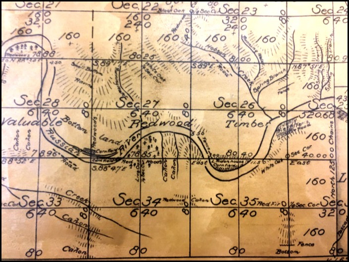
Across this map are the words, "Valuable Redwood Timber." In 1866, Anthony and Melissa McPeak owned the land around "Valuable" which would later become the Korbel property. Below where it says "Bottom Land" is a little rectangle that says, "corn field." That is Anthony's corn field. In a few years he would be moving over to Hobson Creek, around where it says "Timber." There was not much going on in 1866. The train doesn't arrive for ten more years.
Across this map are the words, "Valuable Redwood Timber." In 1866, Anthony and Melissa McPeak owned the land around "Valuable" which would later become the Korbel property. Below where it says "Bottom Land" is a little rectangle that says, "corn field." That is Anthony's corn field. In a few years he would be moving over to Hobson Creek, around where it says "Timber." There was not much going on in 1866. The train doesn't arrive for ten more years.
1867
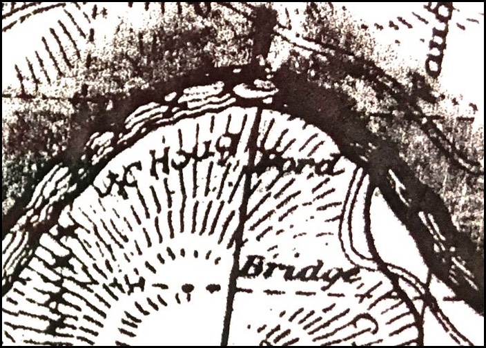
The Walls Ford Bridge did not exist until 1898, so this was still a ford, one crossed through the river. It says "Ford" at the river crossing, and "Bridge" where the road crosses Green Valley Creek.
The Walls Ford Bridge did not exist until 1898, so this was still a ford, one crossed through the river. It says "Ford" at the river crossing, and "Bridge" where the road crosses Green Valley Creek.

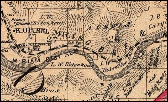
1877
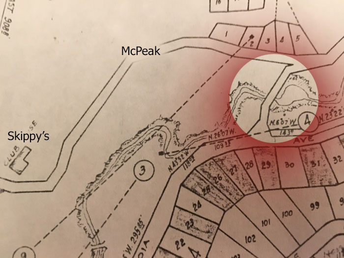
This map shows small black boxes for buildings. The one next to the word "McPeak" is the McPeak home. That would place it near where Marigold branches off from McPeak Road in 2017. The black box further west on Westside Road below the number 26 is the Ridenhour home.
A&M McPeak probably stands for Anthony and Matthew, Anthony's father, McPeak. Anthony also had a brother named Matthew. Later maps show only Anthony McPeak.
1877 to the east
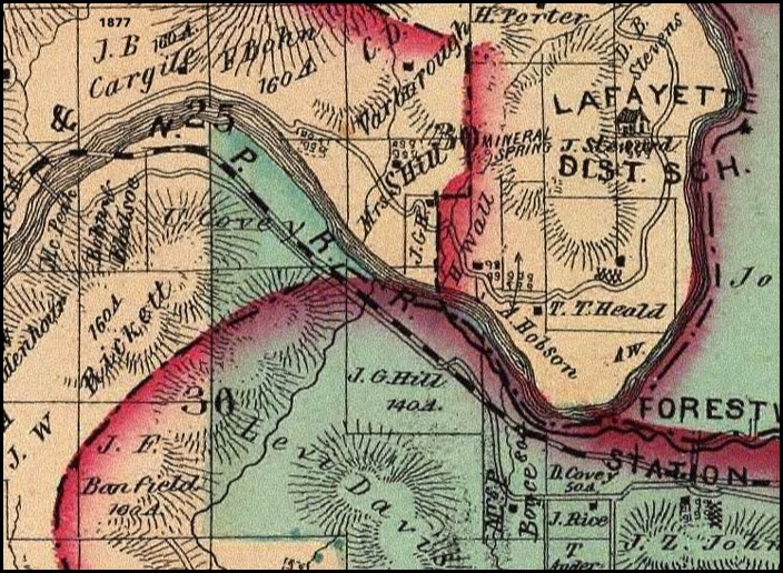
Near the center is an indication of "Mineral Springs" which could be the location of Wall's Resort. Where the river dips furthrest south, we can see the property marked A. Hobson. This where the Hobsons moved after they sold Hobson farm to the McPeaks. Their house is the black box near the "H" in Hobson. The Forestville train station is at bottom right.
Near the center is an indication of "Mineral Springs" which could be the location of Wall's Resort. Where the river dips furthrest south, we can see the property marked A. Hobson. This where the Hobsons moved after they sold Hobson farm to the McPeaks. Their house is the black box near the "H" in Hobson. The Forestville train station is at bottom right.
1877 to the west
In 1877, there was a post office at Korbel Mills, though the post office there only operated for about four years.
In 1877, there was a post office at Korbel Mills, though the post office there only operated for about four years.
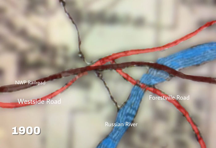
1900
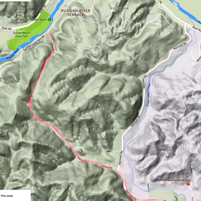
I found this map interesting due to the road from Forestville to Cosmo / Hacienda. It appears to follow current Martinelli Road part of the way then cut behind Summerhome Park before crossing at the shallow river location. I looked at a topo map to see if there was a valley that road might have followed and the most likely path is shown on the lower map.
I found this map interesting due to the road from Forestville to Cosmo / Hacienda. It appears to follow current Martinelli Road part of the way then cut behind Summerhome Park before crossing at the shallow river location. I looked at a topo map to see if there was a valley that road might have followed and the most likely path is shown on the lower map.
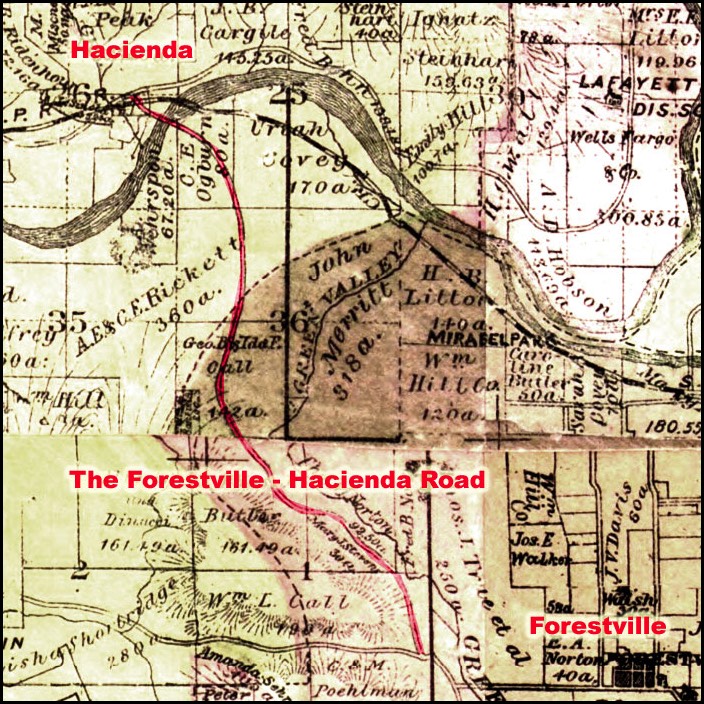
1907 detail
Hand drawn map with approximate locations. Of note: The Forestville to Cosmo road is the one that follows Green Valley Creek and then cuts across behind Summerhome Park, fording through the river at Cosmo. On that road is a notable building marked "MERRITT" which is a school. This map shows a road from Mirabel Park connecting to the road to Cosmo, which is not seen in the previous map from seven years earlier. Also, no Guerneville Bridge. The bridge there was built in 1922. In the upper-right corner, the intersection shown is where Sweetwater Springs Road joins Westside Road. At this time Sweetwater Springs Road (near the 17) was the road that went to Guerneville since Westside Road ended at Korbel.
Hand drawn map with approximate locations. Of note: The Forestville to Cosmo road is the one that follows Green Valley Creek and then cuts across behind Summerhome Park, fording through the river at Cosmo. On that road is a notable building marked "MERRITT" which is a school. This map shows a road from Mirabel Park connecting to the road to Cosmo, which is not seen in the previous map from seven years earlier. Also, no Guerneville Bridge. The bridge there was built in 1922. In the upper-right corner, the intersection shown is where Sweetwater Springs Road joins Westside Road. At this time Sweetwater Springs Road (near the 17) was the road that went to Guerneville since Westside Road ended at Korbel.
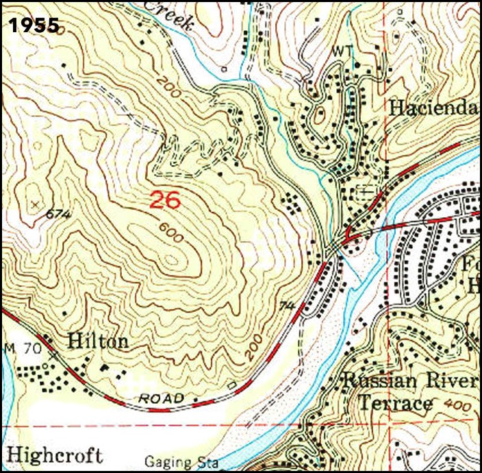
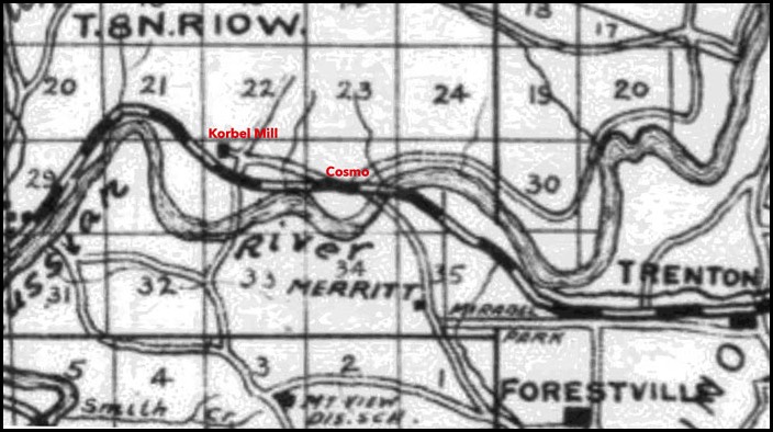
1955
Much as it is today. The McPeak Cemetery is marked by a cross.
Much as it is today. The McPeak Cemetery is marked by a cross.
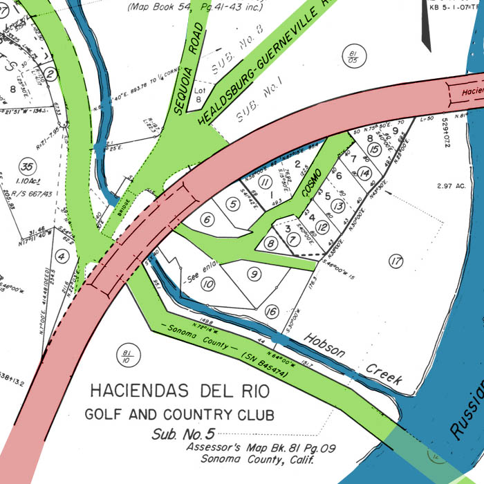
SONOMA COUNTY ASSESSOR'S MAP (WITH ADDED COLOR)
I do not know the date of this, but there is no Sunset Avenue, and it is referred to as "Haciendas Del Rio."
Of interest is the road marked "Sonoma County" that passes through Russian River. This is the shallow river crossing point, the ford, which was the way to get to the west side of the river before the Hacienda Bridge was built. This is also the site of the Hacienda Summer Bridge that was constructed each summer starting in 1927.
Hacienda Inc. on the west side and A.B. Swain on the east side each deeded a 40 foot wide strip of land to Sonoma County to build road access to the Summer Bridge that connected the two sides of the river. This was no longer used once the Hacienda railroad bridge was converted to automobile usage.
Bridges. Who doesn't love a bridge? Foot, horse and buggy, trains, cars. Human ingenuity challenging nature.
Crossing Hobson Creek part 1
I have tended to treat Westside Road much as though it was a road as it is today. This was not at all true. Westside Road as a through road dates back to 1937. Previously to that, Healdsburg had its "West Side, " a kind of wild nowhere area off to the west. The West Side road was just a dirt road or a series of roads that went different places on that side of the town that one could use to go to areas down the river. Before those roads, if you would call these dirt trails "roads," horse riders and buggies would follow the river, riding on beaches and bank edges to work their way down stream.
One would ride through shallow water as necessary. Creeks that flowed in from the side were usually easiest to cross at the river as ravines could be steep. Such was the case at Hobson Creek. The ravine is quite deep at Cosmo.
So I believe travelers on West Side Road before the railroad came in originally crossed down to the beach as the way for bypassing Hobson Creek.
Before the railroad came through and cut West Side Road in two, what is labeled as the "old Road" indicated by red color on the below map, continued into present day "Cosmo Court." I think that before the railroad, horse riders went down to the beach to get around Hobson Creek.
When the railroad came though, the builders bent the old road back and made a straight connection which is colored blue and labeled "County Road." They added the connector road under the trestle to connect to the houses on the east side of the railroad. We call that Cosmo Court now. The railroad company built a one-lane bridge over Hobson creek for horses and buggies on this County Road, in the green circle.
Then in 1930, the county built a bridge across Hobson Creek more suitable for the increased traffic on the road that is now called Westside Road.
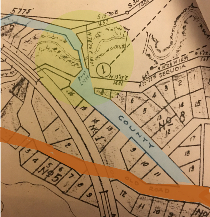
The above map is dated 1926 and is from the survey for Haciendas del Rio.
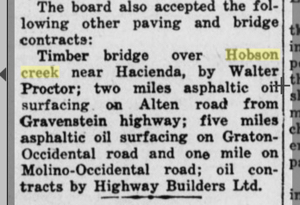
In July 1930, the country approves a bridge for Hobson Creek. Shown below.
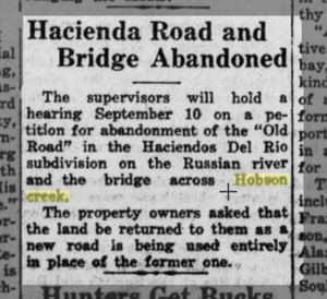
In August 1930, Hacienda Inc. requested that land be returned to them from the "Old Road" and the old Hobson Bridge which were no longer in use.
The Hobson Bridge built in 1930.
I have not found evidence to support this idea, but it tends to be logical.
Crossing Hobson Creek part 2
The train crossed Russian River starting in 1876. That, of course, is a big deal. But that train also crossed Hobson Creek on a new trestle. The train stop was just west of that trestle. There are pictures of that trestle on this page.
That all worked fine until 1937. The railroad bridge over the Russian River was converted to a one-lane car bridge. However, the trestle was not converted to automobiles, and just sat as a romanic reminder of the old days. Cars would come off the river bridge and zip down the incline onto Westside Road, cross the 1930s Hobson Bridge, then up the incline on the other side to get to River Road again.
This was the way it worked for 10 or 12 years. Then the river bridge was widened in 1946-47 and Sonoma County realized the trestle had to be replaced by a modern automobile bridge and traffic had to stop using the bypass on Westside road. So we got a concrete bridge.
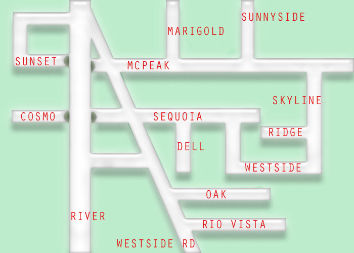
The Westside Road/ River Road/ Sequoia Road/Cosmo Court/Sunset Ave/McPeak Road has been a confusion for drivers ever since.
That all worked fine until 1937. The railroad bridge over the Russian River was converted to a one-lane car bridge. However, the trestle was not converted to automobiles, and just sat as a romanic reminder of the old days. Cars would come off the river bridge and zip down the incline onto Westside Road, cross the 1930s Hobson Bridge, then up the incline on the other side to get to River Road again.
This was the way it worked for 10 or 12 years. Then the river bridge was widened in 1946-47 and Sonoma County realized the trestle had to be replaced by a modern automobile bridge and traffic had to stop using the bypass on Westside road. So we got a concrete bridge.
The Westside Road/ River Road/ Sequoia Road/Cosmo Court/Sunset Ave/McPeak Road has been a confusion for drivers ever since.
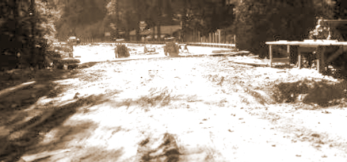
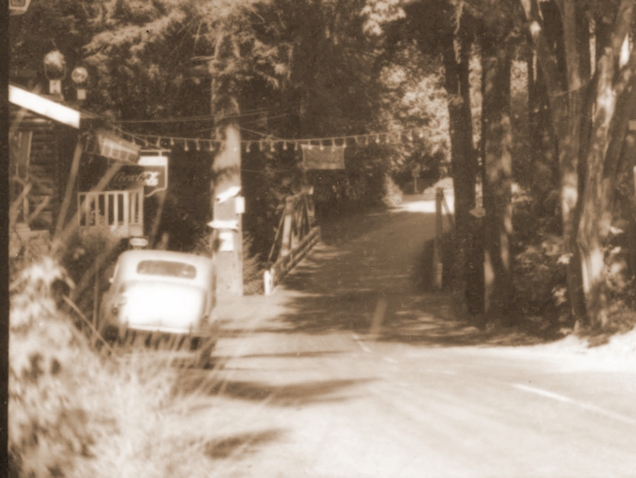
The 1950 Hobson Bridge under construction. Center distant is TOPS Club.
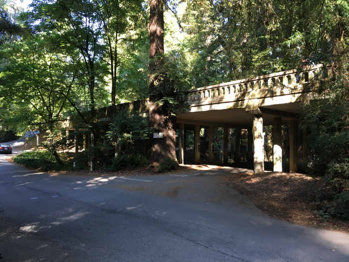
The 1950 Hobson Bridge as it appears in 2017. While it is included on the website, UglyBridges.com, i think it has a quality of Greek revival. http://uglybridges.com/1042491
While on the subject of Hobson Creek, there was another bridge. This bridge crossed between Sequoia and McPeak. I don't know when it was originally built, nor when it was removed. This is not the crossing on Skyline. It appears on a 1926 map.
Before the train came through. Before 1876, the only actual road that counted was one from Healdsburg that went to the Ridenhour Ranch. West Side Road. There was a road from Forestville on the other side of the river so one could cross through the river and get to West Side Road.
I feel rather certain that West Side Road followed the route we now know as Cosmo Court and also Sunset Avenue. The road continued from what we know as Sunset Avenue through the, now, Sunset Regional Park to the Ridenhour home which still stands opposite the parking area of the regional park.
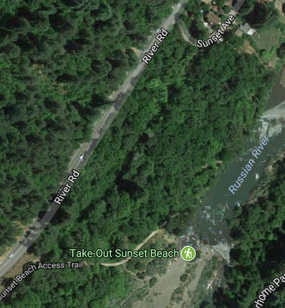
This satellite photos from Google show this road used to exist.
I feel rather certain that West Side Road followed the route we now know as Cosmo Court and also Sunset Avenue. The road continued from what we know as Sunset Avenue through the, now, Sunset Regional Park to the Ridenhour home which still stands opposite the parking area of the regional park.
This satellite photos from Google show this road used to exist.
The hand drawn map from 1900 shows that Westside Road continued to be "Sunset Avenue" even after the railroad was built.